
Chapelgarth
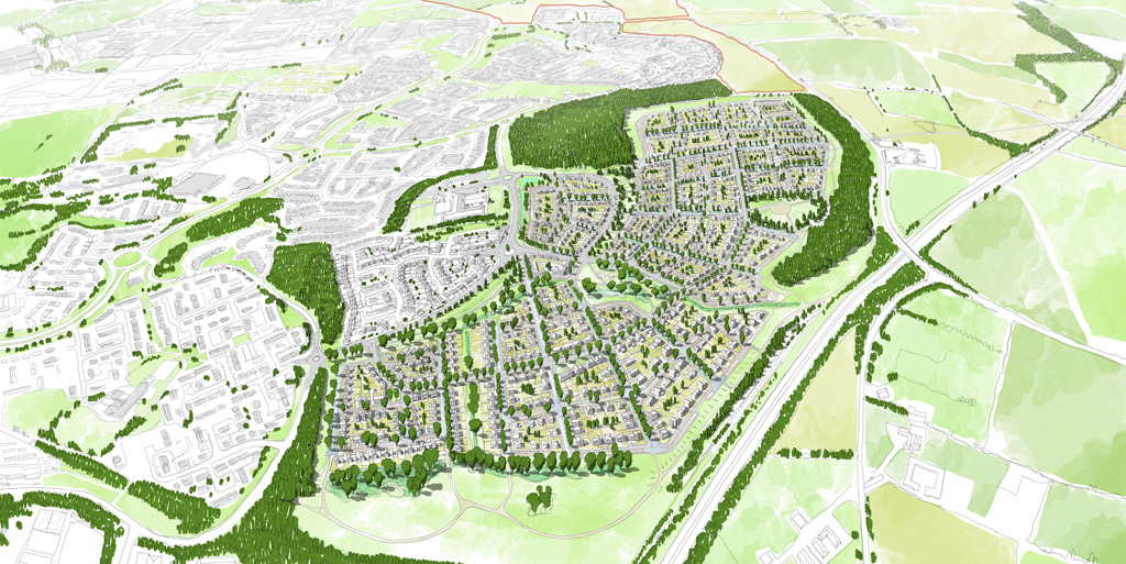
A major housing development is proposed at Chapelgarth’s 112 acre site. The plans for Chapelgarth include village style neighbourhoods each with their own character and in a landscape setting with open spaces that are accessible for people to enjoy, protecting the woodland areas that surround the development.
The masterplan has been influenced by the existing landscape and natural features of the site. Local landscape architects, Colour, have developed a landscape strategy to preserve sensitive areas of the site, enhance the natural green space and provide parks and green spaces for both new and existing residents to enjoy.
There will be recreational routes through the site which form a continuous circuit through the scheme. These routes are based on existing well-loved footpaths, and our aim has been to formalise and improve these routes.
GREEN SCHEME
There will be a generous green buffer between Weymouth Road and the new development, with drainage ponds which will look like grassed basins and will only fill with water during extreme storm events. This means that most of the time they can be enjoyed as parkland.
Central Park
At the heart of the scheme is a newly created neighbourhood park, Central Park, which is defined by existing mature trees and hedgerows. A network of footpaths will permeate the park and a play space will be provided to attract young children and families
Retaining Natural Greenspace
Siglion has made green space a priority at Chapelgarth. We have allocated 13.5 hectares of ‘Sustainable Alternative Natural Greenspace’ (SANG) on this masterplan – the equivalent in area to over 18.2 full size football pitches.
We are proposing to add new footpaths to make it as accessible to all ages as possible, and link it to existing cycle routes. SANGs provide alternative recreational spaces which can help reduce visitor pressure on other areas along the coast which are home to protected bird species.
SUSTAINABLE URBAN DRAINAGE
Sustainable Urban Drainage Strategy:
A detailed drainage strategy, submitted as part of the planning application, will manage water movement and storage around the site. It will cut the amount of water that runs into existing water courses in and around the site by adding a sustainable, high quality drainage system.
The drainage system will reduce any localised flooding through surface water drainage improvements and the use of sustainable urban drainage techniques to reduce the run off from the development.
We are working with engineering specialists to integrate solutions to flooding risk at Chapelgarth, and manage the possibilities of extreme storm events as a consequence of climate change over the next 100 years. SUDs means the most effective and up-to-date drainage technology will be used, and is a requirement of Sunderland City Council and Northumbrian Water.
It will include:
- Standard Roads with swales drainage ponds
- Swales along streets to hold water. Swales are shallow vegetated channels designed to slow surface water run off
- Drainage ponds – these will retain water in the event of a severe and prolonged storm, and will discharge it slowly into the water sewer, so as not to inundate it
- Trees will be planted to capture surface water run off along new streets
SPACES FOR PEOPLE
All residents will live no more than a seven minute walk (500m walk) from at least two hectares of accessible woodland, in line with The Woodland Trust’s Woodland Access Standard Nature Nearby.
All residents will live no more than a five minute walk (300m) from at least two hectares of accessible green space in line with Natural England Accessible Natural Greenspace.
